State and local highway crews are preparing for a long weekend in the wake of an approaching winter storm.
According to Kentucky Transportation Cabinet, the District 1 Snow & Ice Team is actively monitoring the system, which is expected to arrive in western Kentucky Thursday night into Friday morning. If the current forecast holds, this wintry precipitation followed by plummeting temperatures is likely to have a substantial impact on travel across the region.
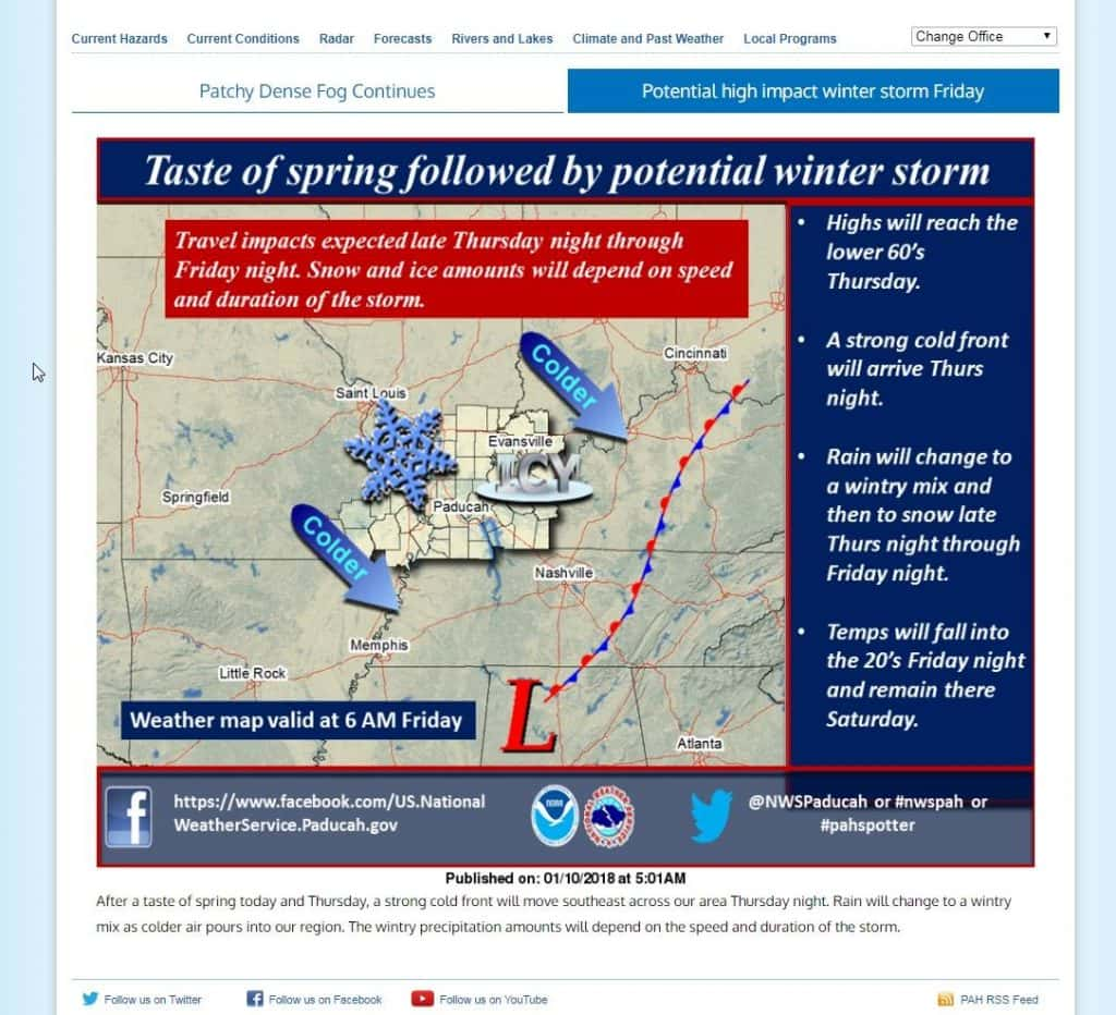
Based on information available this morning, Jan. 10, the forecast indicates the region will get intermittent rain on Thursday that will transition into freezing rain with a wintry mix and sleet on Thursday night to be followed by maybe 2 inches of snow during the day on Friday.
The Snow & Ice Team is evaluating the potential effectivness of some pre-treating activities on Thursday. The team is awaiting additional info on rain totals expected prior to the start of winter precipitation before making a decision on pre-treating.
KYTC crews as of this morning were considering pre-treating for Interstates and Parkways, along with bridges, overpasses, and potential trouble spots on other routes. Again, those efforts will be dependent on rainfall estimates in the afternoon forecast update.
Similarly, Marshall County Road Department crews are making preparations for the coming storm as well. MCRD issued a statement on social media this afternoon urging residents to use caution and exercise patience. Like KYTC, local crews were awaiting rainfall estimates before making a decision on pre-treating roads.
“Please travel with caution and allow yourself plenty of time,” MCRD said on its page. “Please have patience as our crews run our snow routes, as all 884 roads will be ran, but this does take an average of 8 hrs.+ to complete.”
KYTC cautioned that pre-treating with brine was only as effective as circumstances allowed.
“Pre-treating with brine requires a fairly specific set of circumstances,” a KYTC release said. “KYTC crews generally do not pre-treat if more than about a 3/4-inch of rain is expected because it would wash away the pre-treating material. Temperatures below about 18 degress prohibit pre-treating as the brine has the potential to flash-freeze when it hits the pavement, possibly creating slick spots. It takes about two full days for KYTC District 1 crews to pre-treat all 2,800 miles of highway in the 12-county region.”
Brine is produced by running water through salt. The liquid is then sprayed on roadways where it dries to a fine powder until it is activated in the early hours of a snow and ice event. It helps improve driving condtions early-on in a snow and ice event. It also prevents snow from bonding to the pavement surface making it easier to plow off as the winter event progresses.
While pre-treating with brine, and following treatment with salt can be highly effective for snow events, it has limited benefits during events that include freezing rain and sleet prior to the arrival of snow. The wintry mix anticipated prior to the start of snow could limit the ability of highway crews to improve driving conditions, particularly in the early hours of this event.
KYTC urged drivers to pay close attention to the local forecast as accumulation numbers could change as the storm approaches. In particular, drivers should carefully consider limiting travel until highway crews have time to salt and plow snow, according to KYTC.