|
PADUCAH, Ky. (Feb. 17, 2025) – High water is impacting numerous roads in KYTC District 1. While some roads have reopened, many remain closed due to flooding and new roads are being added to the closure list.
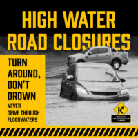
High water remains possible even for roads not listed. Drivers are urged to check traffic conditions before traveling at GoKy.ky.gov. Remember, never drive through a flooded roadway. Turn around, don’t drown.
List of roads in District 1 impacted by high water:
Please note this list only includes state routes. Flooded roads added throughout the day will be listed as NEW. Roads in which water has receded are listed below as 𝗖𝗟𝗘𝗔𝗥 and will then be removed from the list during the next update.
Ballard County
KY 62 is closed with high water from the 1.1 MM/KY 1837 near Lovelaceville to the 9 MM/KY307.
Calloway County
KY 464/Almo Road is closed with high water at the 13 MM at Clark’s River.
One road is open with high water and signs are posted. It is:
KY 299/Butterworth Road, 0.7 MM, north of KY 94 W.
Carlisle County
KY 1820 is closed with high water between the 1-3 MM (Wilson Creek). This starts near the intersection of KY 1628.
KY 1628 is closed with high water between the 3-4 MM (Wilson Creek). This is between KY 1820 and U.S. 62.
KY 1820 is closed with high water at the 6 MM, east of U.S. 62.
KY 1591 is closed at the 1.5 MM due to a sinkhole caused by flooding. This is between KY 877 and Cherry Road.
U.S. 62 is closed with high water at the 12.5 MM. – NEW (from overnight)
U.S. 62 is open at the 4 MM near the West Fork Creek Bottoms. – 𝗖𝗟𝗘𝗔𝗥
Fulton County
KY 94 (Lower Bottoms) is closed with high water between 9.1 MM (Parker Lane) to 10.9 MM (1099 Bypass).
KY 94 is closed due to a slide caused by flooding at the 12.0 MM from Kentucky Street to Cumberland Street in downtown Hickman city limits.
Graves County
KY 408 is closed with high water between the 9.2-10 MM. This is between Ethel Road and McCracken County Road, approx. 1 mile east of U.S. 45.
KY 1241 is closed with high water at the 10 MM (Mayfield Creek), west of U.S. 45 and at the intersection of 1820.
Hickman County
KY 123 is closed with high water between the 14-16 MM in the Hailwell Corner area.
KY 3061 is closed from the 0-2.366 MM due to pipe failure.
KY 780 is closed with high water between 2-3 MM. – NEW (from overnight)
KY 239 is open between the 0.518-3.75 MM. – 𝗖𝗟𝗘𝗔𝗥
U.S. 51 N is open between the 14-15 MM near the Hickman-Carlisle County Line. – 𝗖𝗟𝗘𝗔𝗥
U.S. 51 S is open between the 4-5 MM. – 𝗖𝗟𝗘𝗔𝗥
Livingston County
No roads are currently closed due to high water.
Several roads are open with high water and signs are posted. Those include:
KY 60, 11-12 MM.
KY 917/Stringtown Road, 1-2 MM, north of U.S 62 near the Livingston-Lyon County Line.
KY 723, 4-5 MM.
KY 70, 3-4 MM.
Lyon County
KY 1943 is closed with high water between the 3-4 MM near Skinframe Creek Bridge.
KY 819 is closed with high water between the 2-3 MM.
Marshall County
KY 1462/Benton-Birmingham Road is closed with high water between 0-1.3 MM. This is between KY 408/E. 12th Street and KY 1477/Benton Briensburg Road.
KY 1949/Wadesboro Road is closed with high water at the 7.4mm at the I-69 Tunnel.
U.S. 641/Main Street in Benton is closed with high water from 9.2 to 9.7 MM, between Benton Ford and the Pizza Hut.
KY 58 is closed at the 1.3 MM due pavement undermined caused by flooding, east of the Graves-Marshall County Line.
McCracken County
KY 1255/Bonds Road is closed with high water between the 0.0 MM (KY 348/Hardmoney Road) and the 2.3 MM (KY 450/Oaks).
KY 339 is closed with high water from the 0-2 MM.
KY 787 is closed with high water from the 0-1.3 MM (Bypass Road).
KY 348 closed with high water between the 7.2 MM/Graves-McCracken County Line to the 5.6 MM/McNeil Road.
KY 131 is closed with high water from 1.2 MM/Bypass Road over the McCracken-Graves County Line to 12.9 MM/KY 348 in Symsonia.
KY 1255/Bonds Road is closed with high water at the intersection with KY 450/Oaks at the 2.3 MM.
KY 450/Oaks Road is closed with high water from 3 MM/Shemwell Road to the 1.2 MM/KY 348 intersection over the McCracken-Graves County Line.
Trigg County
KY 1507/Barefield Road is closed with high water at the 1.0 MM. This is between U.S. 68/Hopkinsville Road and KY 958/Montgomery Church Road.
KY 128 is closed with high water between the 0.0 MM at U.S. 62 and the 1.0 MM, just past the intersection of Dunkerson Road.
KY 525/New Hope Road is closed with high water at the 4 MM. This is near the intersection of Prather Road.
KY 124/Cerulean Road is closed with high water between the 9-10 MM near the Trigg-Christian County Line.
KY 1253/Hardy Road is closed with high water between the 3-5 MM.
KY 126 is closed with high water at the 4 MM.
KY 276 is closed with high water between the 13-14 MM.
KY 276 is closed with high water at the 9.1 MM/KY 128 intersection, near Wallonia.
KY 958 is closed with high water between the 1-2 MM.
KY 272 is open between the 6-7 MM. – 𝗖𝗟𝗘𝗔𝗥
KY 139 is open between the 16-17 MM, near U.S. 68x. – 𝗖𝗟𝗘𝗔𝗥
++++
To get traffic advisories and alerts for KYTC District 1 counties via email, please go to https://public.govdelivery.com/accounts/KYTC/signup/13651. Click on the District 1 counties you regularly drive through, or on any of the specialty corridors you travel. Check your SPAM filtering to ensure Gov Delivery is on your approved list.
Timely traffic advisories for the 12 counties of KYTC Highway District 1 are available by going to www.facebook.com/kytcdistrict1. Please LIKE or FOLLOW District 1. You do not have to be a Facebook member to access this page.
###
|